Dwayne Hodgson

A Portfolio

The work and adventures of Dwayne Hodgson,
+ Learning Designer & Facilitator at learningcycle.ca
+ Storyteller & Photographer @ thataway.ca

Filtering by Tag: travel by map

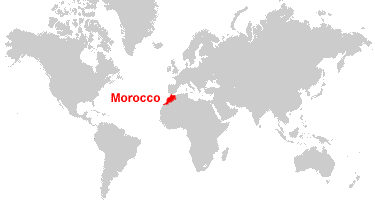
Travel by Map #7: The Netherlands

May 11 to June 1, 2015

We did a lot of to-ing and fro-ing by bike, train, bicycle, hand-cranked ferry boat, car, bicycles, bus, tram, canal boat, and in Zoe's case, by horse. It's a bit hard to guesstimate, but we probably covered something like 1,200 km once you add in the side trips.

And this being the Netherlands, a good portion of our time was spent below sea level. 

Travel by Map #6: United Kindgom

United Kingdom:
England & Scotland

During our nearly five weeks in the United Kingdom, we travelled close to 2,500 km by train in southwest England, car in Scotland, and punt in Oxford, not including several hundred kilometres around London on the Underground

Here is an interactive map of our journey. 

The London Underground

Here is a map of the subway system in London